GEN 2 TABLES AND CODES
GEN 2.1 MEASURING SYSTEM, AIRCRAFT MARKINGS, HOLIDAYS
1 Units of Measurement
1.1 The units of measurement used in all air and ground operations are in accordance with Annex 5, including those shown below commonly used for the dissemination of information and in messages transmitted to aircraft.
| QUANTITY | UNIT OF MEASUREMENT |
|---|---|
| Distance used in navigation # | Nautical Miles (NM) * |
| Relatively short distances (e.g. runway length) | Metres (m) |
| Altitudes, elevations and heights | Feet (ft) or metres (m) |
| Horizontal speed including wind | Knots (kt) |
| Vertical speed | Feet per minute (ft/min) |
| Wind direction for take-off and landing | Degrees Magnetic (°M) |
| Wind direction except for take-off and landing | Degrees True (°T) |
| Visibility (including RVR) | Metres or Kilometres (m, km) |
| Barometric pressure | Hectopascals (hPa) |
| Temperature | Degrees Celsius (°C) |
| Weight | Tonnes or Kilogrammes (t, kg) |
| Time | Hours and minutes, the day of 24 hours beginning at midnight UTC (hhmm) |
| # In geodesic or Great Circle distance * International nautical miles, for which conversion into metres is given by: 1 nautical mile - 1 852 metres. |
|
2 Time System
2.1 Co-ordinated Universal Time (UTC) is used in the air traffic and communication services and in documents published for international distribution by the Aeronautical Information Service.
2.2 Hong Kong Standard Time is 8 hours ahead of UTC. Where the all numeric date/time form is used in NOTAM, messages and aeronautical documents, this is presented in the sequences of year-month-day-time (yymmddtttt). It should be noted that normally the year digits may be omitted where no possible confusion could arise from such an omission.
3 Geodetic Reference Datum
3.1 Name/designation of datum
3.1.1 All published geographical co-ordinates within Hong Kong airspace indicating latitude and longitude are expressed in terms of World Geodetic System - 1984 (WGS-84) geodetic reference datum.
3.2 Area of application
3.2.1 Area of application for the published geographical co-ordinates coincides with the area of responsibility of the Aeronautical Information Service, i.e. the entire Hong Kong FIR in accordance with the regional air navigational agreement.
4 Vertical Reference System
4.1 Hong Kong Principal Datum (HKPD) is the vertical reference system used in Hong Kong, which is about 1.30 metres below Mean Sea Level (MSL) as at 2016.
4.2 HKGEOID2016_SMO is the Geoid Model used in Hong Kong which corresponds to HKPD for GNSS heighting.
4.3 Altitudes (ALT) and Elevations (ELEV) expressed in AIP Hong Kong are measured from Mean Sea Level (MSL) as per ICAO definition.
4.4 Differences between the altitudes referenced to The Earth Gravitational Model - 1996 (EGM-96) and HKGEOID2016_SMO:
4.4.1 The differences between the orthometric heights referenced to EGM-96 and the orthometric heights referenced to HKGEOID2016_SMO (that is, the differences between the undulations of both geoids) depend on the geographic location of the point under consideration. The following map shows the undulation differences of these models in Hong Kong.
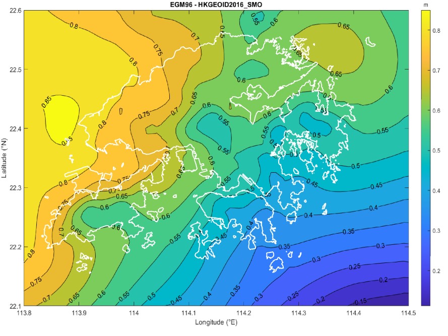
Differences between EGM-96 and HKGEOID2016_SMO (that corresponds to HKPD)
5 Aircraft Markings
5.1 The nationality mark for aircraft registered in Hong Kong is the letter ‘B’. The nationality mark is followed by a hyphen and a registration mark consisting of a three letter group. The first letter of the registration mark being the letter ‘H’, ‘K’ or ‘L’, representing Hong Kong. Registration marks are issued within the combination ‘HAA’ to ‘HZZ’, ‘KAA’ to ‘KZZ’ and ‘LAA’ to ‘LZZ’.
6 Public Holidays
6.1 Annual public holidays are notified in Aeronautical Information Circulars.