ENR 5.3 OTHER ACTIVITIES OF A DANGEROUS NATURE AND OTHER POTENTIAL HAZARDS
1 Avoidance of Disaster Area(s)
1.1 Disasters, particularly those involving installations or carriers of gas, oil or chemicals, may produce an immediate risk of explosion, fire and surface pollution which, in addition, may cause the release of gases which may be noxious or explosive or both.
1.2 In the event of a disaster occurring on land or at sea within the territory of Hong Kong, the Civil Aviation Department may consider it necessary for the safety of life and property, and particularly for the protection of those subsequently engaged in search and rescue, to inhibit flights in the vicinity of the disaster by aircraft not directly engaged in emergency actions, by establishing a temporary Danger Area around the scene of the disaster. However, if the temporary Danger Area fails to achieve this objective, statutory Restriction of Flying under Article 69 of The Air Navigation (Hong Kong) Order 1995, which makes it an offence for an aircraft to be flown in the designated area without appropriate permission, will be brought into effect. Details of temporary Danger Areas and Restriction of Flying will be promulgated by NOTAM.
2 Release of Radio-sonde MET Balloon
2.1 Radio-sonde MET balloons are released by the Hong Kong Observatory twice a day, at 1130 and 2330 UTC plus once a week every Wednesday at 0530 UTC, from King's Park Meteorological Station (Hong Kong International Airport ARP 090º/27 km).
2.2 The balloon is red in colour and has a diameter of 1.5 m at ground level; a parachute and an instrument box are tethered 1.5 m and 60 m respectively below. It rises at a rate of about 1 200 ft per minute and can reach a height of 90 000 ft.
3 Penny’s Bay Gas Turbine Power Station
3.1 A gas turbine power station at Penny’s Bay may operate and produce high temperature plumes within a radius of 0.27 NM (0.5 km) of UTM Grid Ref JK952713, up to an altitude of 1 500 ft AMSL. (This area is wholly within Restricted Area VHR12 Penny’s Bay.)
4 Laser and Searchlight Display
4.1 A laser and searchlight display takes place every evening from the buildings along the Central, Wanchai, Tsim Sha Tsui and Kowloon Bay Districts’ waterfront during the period 1200 to 1213 UTC daily.
4.2 The laser beams are confined to an altitude band of 600 ft to 1 500 ft AMSL so as to mitigate visual distraction to pilots.
4.3 RESTRICTIONS TO AIRCRAFT AND HELICOPTER OPERATIONS
4.3.1 Aircraft and helicopters shall remain clear of the area bounded by UTM Grid references KK072671, to KK079681, to KK119713, to KK130691, to KK091667 then along the coastline to KK072671, up to an altitude of 1 500 ft AMSL, during the period of the laser and searchlight display.
4.3.2 If there is an operational requirement for an aircraft or helicopter to enter the above area during the period of the laser and searchlight display, except for emergency situations, the operator must obtain the prior approval of the Director-General of Civil Aviation.
4.4 There are no operational restrictions to the use of Sky Shuttle Heliport.
5 Fireworks Displays
5.1 At Disneyland
5.1.1 A fireworks display lasting for 20 minutes is held every evening at Hong Kong Disneyland, during the period 1100 -1430 UTC, subject to weather conditions. The fireworks are contained within a radius of 0.54 NM (1 km) of UTM Grid Ref JK956706, up to an altitude of 1 100 ft AMSL. (This area is situated inside Restricted Area VHR12 (Penny’s Bay) as described in ENR 5.1)
5.2 At Victoria Harbour
5.2.1 Fireworks displays lasting about 25 minutes are held in Victoria Harbour (area around UTM Grid KK085675) to celebrate special occasions of the year. The date, time and affected airspace will be promulgated by NOTAM.
5.2.2 During the fireworks display period, aircraft operating in the CTR Island Zone shall keep clear of the published NOTAM area. Flights departing from or arriving for Hong Kong International Airport shall not deviate and overfly the Victoria Harbour.
6 Tung Chung - Ngong Ping Cable Car
6.1 An aerial cable car is in operation at the southern perimeter of the airport. The cable car links Tung Chung with Ngong Ping Peak on Lantau Island (see chart page AD 2-VHHH-VFR-3).
6.2 Between Tower 2B, 190 ft AMSL (Hong Kong Airport southern perimeter) and Tower 3, 1 023 ft AMSL (Nei Lak Shan), the ropeway spans Tung Chung Bay up to a height of 694 ft AMSL. Helicopters operating in the Tung Chung Bay area shall visually maintain safe clearance from the ropeway.
6.3 All cable car support towers are lit and the ropeway over Tung Chung Bay is marked with orange and white day markers and red lights at night.
7 Local Rock Blasting
7.1 Rock blasting is carried out at a number of locations in Hong Kong. Refer to the AIP Supplement for details.
8 Wind Turbines
8.1 Wind turbine erected at Lamma Island PSN: 22 13 32.16N 114 07 15.10E Height 535 ft AGL.
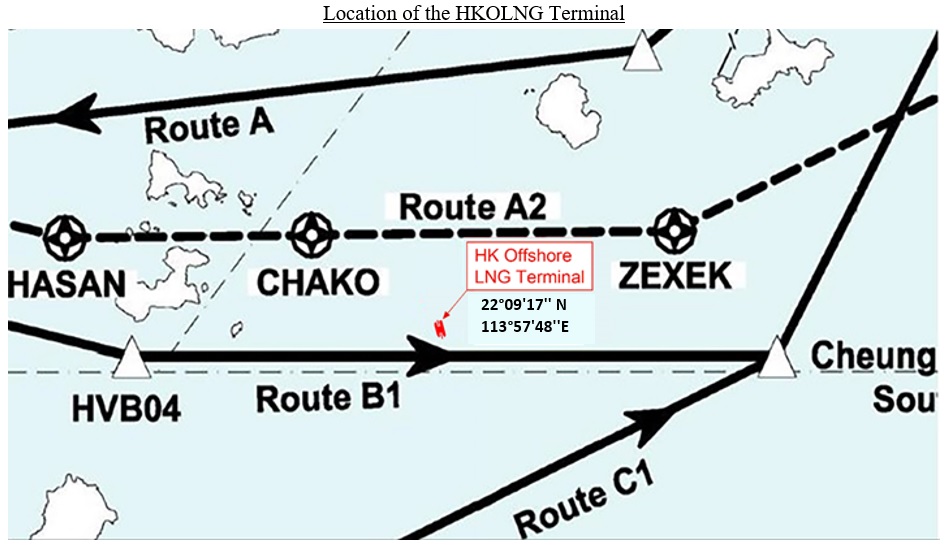
9 Hong Kong Offshore Liquefied Natural Gas Terminal
9.1 The Hong Kong Offshore Liquefied Natural Gas (HKOLNG) Terminal is located to the east of Soko Islands, in close proximity to the Hong Kong – Macao VFR/SVFR Helicopter Routes A2 and B1 (see the diagram below).
9.2 The maximum height of the Terminal is up to 83.9 m or 275 ft AMSL. During its operations, the closest distance between the LNG carrier and the Hong Kong – Macao VFR/SVFR Helicopter Route B1 is about 374 m.
9.3 Aviation Obstacle Lights are installed at the highest points of the superstructures and lifting equipment in the Terminal.
9.4 Advice to Helicopter and Aircraft Operators
9.4.1 Local VFR/SVFR traffic (helicopter and fixed-wing light aircraft) should avoid flying over the Terminal.
9.4.2 Pilots are reminded to adhere to the relevant flight procedures published in AIP ENR 3.4 and remain vigilant when operating in the airspace near the Terminal.